KENTVILLE, N.S. — What is it?
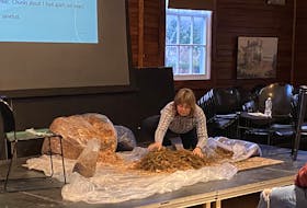
That question was asked time and again at “The Great Kings Historical Society Show and Tell” at the Kings County Museum in Kentville on April 30.
The historical society hosts the show and tell once a year. Society members and members of the general public show up with interesting items or stories to share. Occasionally, people bring objects that they can’t identify. They look to the collective wisdom of the society to see if someone can offer some clarification.
Kings Historical Society member Allison Magee brought an item of great cultural significance to the Iroquois First Nations: a turtle rattle used in ceremonies to help heal or cure various health ailments.
It might have served to distract a patient from something unpleasant or to create more of a sense of ceremony because “sometimes showmanship adds to it.”
“Many different Indigenous peoples have done this and you can tell from the type of turtle which nation it likely comes from,” Magee said.
Dried beans inside the turtle produce the rattling sound. Magee said different Indigenous peoples used the rattles in different ways.
He got the rattle from an antique dealer but you can find various forms of them for sale online. Magee said he wouldn’t be surprised if there was a piece of wood inside the neck to give the rattle more stability.
Stories about turtles are part of various Indigenous cultures. Magee said the turtle is of great significance to the Iroquois because of their creation story. It explains how the land mass of North America was formed by animals putting mud on the back of a massive turtle.
MILE MARKER 27
Nathan Schofield of North Alton brought a piece of Valley railway history that he found in the bushes while biking along the former rail bed close to Wilmot: The Dominion Atlantic Railway (DAR) mile marker 27 for the Kentville subdivision, which ran from Kentville to Annapolis Royal.
With Kentville as mile zero, the markers counted the miles heading west. Schofield said the markers were kind of like GPS coordinates in that era.
A white corner of the sign sticking out from the grass caught his eye. He pulled the metal sign out and found that it was folded over.
“I had my father straighten it out but it was bent over pretty bad,” Schofield said. “I figured if I tried, I would have broke it in half.”
Although it’s a guess, Schofield said the sign probably dates from the 1970s. He has been working the last couple of years trying to reconstruct the post-Second World War history of the DAR. He brought the sign to the show and tell with the hope that he could learn more about it.
BOOK OF MINING MAPS
Helen Archibald of Canard brought a book of maps from the Canada Department of Mines Geological Survey Branch dating from the early 1900s. There were two volumes recording mining sites in Nova Scotia.
Archibald said her father, Charlie Murray, brought the book home in the 1960s and it may be the only one to survive. The books were being disposed of, so he took one. She believes that he was working at the Nova Scotia Technical College at the time.
“I was a kid back then and I remember him bragging that the province was burning them all and he got to keep one,” Archibald said. “He probably hid it and kept it that way.”
She said the book was probably what enthralled her about maps in the first place. She used to work for the federal Department of Fisheries and Oceans labeling river tributaries on maps.
Kings Historical Society president and conservator Kelly Bourassa recommended that cotton gloves be used to handle the book so that oils from people’s hands wouldn’t be absorbed by the paper and linen base used to produce the maps.
“My father used it use it to go prospecting,” Archibald said. “I don’t think he wore cotton gloves.”
RELATED: